
|
|
|
|||||||||
| Carta Marina | ||||||||||
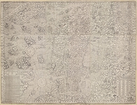
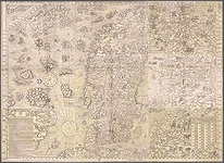
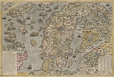
| Olaus Magnus' Carta Marina et Descriptio Septemtrionalium Terrarum, created in 1539, is a map depicting the northern lands, spanning from the south coast of Greenland to the Russian Baltic coasts, including Iceland, the Northern Isles, Sweden, Norway, Denmark, and Finland. It offers the first comprehensive and relatively accurate portrayal of the North, surpassing earlier attempts found in Ptolemaic editions. For many years, the work was thought lost, but a single copy, procured in the sixteenth century and preserved in the Royal and National Library in Munich, was rediscovered in 1886 by Oscar Brenner. The Munich University Library holds a rough hand-drawn copy. In 1558, Niccolò Zeno the younger used the map's data to publish a fictional account of a northern journey allegedly undertaken by his ancestors in 1400, a work that caused a stir until it was later debunked. The map also influenced the work of Sebastian Münster, Gastaldi, and Ortelius. The first edition, known as the Munich copy, was printed in Venice from woodcut blocks and consisted of nine leaves, remaining in circulation for twelve years. The second edition, the Uppsala copy, is held at Uppsala University Library and was engraved in Rome in 1572 on copper plates. Some later reprints were hand-coloured by others. | ||||||||||
| |
||||||||||

  |
||||||||||
|
|
||||||||||
| |
||||||||||
  |
||||||||||


